Helping Satellites connect
To spot fires and predict droughts, satellites need to communicate efficiently with Earth – and data science algorithms can help. Olga Kondrateva, doctoral researcher at the Helmholtz Einstein International Berlin School in Data Science (HEIBRiDS), is programming the satellites to pick and choose what data is worth transmitting.
Olga Kondrateva has always been interested in efficient communication. As an undergraduate in St. Petersburg, Russia, Kondrateva studied applied linguistics, delving deep into the structures that make languages work. Today, she’s a doctoral researcher at the Helmholtz Einstein International Berlin School in Data Science HEIBRiDS, using her programming skills to help satellites communicate better with researchers on Earth.
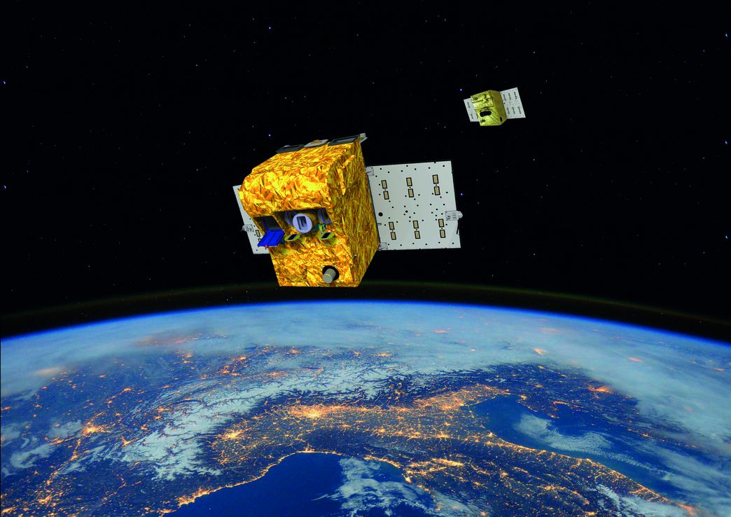
It’s an important job. There are thousands of satellites ceaselessly circling the planet, many of them busy taking pictures and transmitting images back to analysts on the ground. In recent years, pictures taken from these “low -Earth orbit,” or LEO, satellites have been used to guide responses to natural disasters and study the effects of climate change.
LEO satellites are designed to orbit between 500 and 2,000 kilometers above the Earth’s surface, close enough for them to take high-quality images. The low orbit also makes them easier and cheaper to rocket into place.
Constantly moving around the world at 28,000 kilometers per hour
There’s a tradeoff, though: Unlike so-called “geosynchronous” satellites, which orbit from even higher up and remain in a fixed spot above the Earth, LEO satellites are constantly in motion, flying around the globe at around 8 kilometers per second – or 28,000 kilometers per hour.
That means that as LEO satellites fly around the Earth they have only short windows, a few times per day, to beam the images they’ve collected to fixed antennae on the ground. “They gather lots of data, but don’t have the time to transmit it,” Kondrateva says. In a typical 15-minute transmission window, a satellite might be able to pass about only a few hundred megabytes of data down to Earth, depending on the exact configuration. The rest – possibly outdated by the next transmission window – is typically abandoned.
Kondrateva is working on ways to make the process more efficient. Right now, satellites leave the decisions about what images are important to analysts on the ground. By programming the satellites to pick and choose what data is worth transmitting, she hopes to help researchers make the most of each transmission window. “If you can’t get all the data to Earth, you need to decide somehow what you want to transmit,” she says. “I’m creating algorithms to let the satellite decide.”
"If you can't get all the satellite data on Earth, you have to somehow decide what to transmit. I'm developing the algorithms so the satellite can decide for itself."
Olga Kontrateva, doctoral researcher at HEIBRiDS
As part of her doctoral dissertation at HEIBRiDS, Kondrateva is in touch with engineers at the German Space Agency (DLR) and its European partners using LEO satellites to help people on Earth. The approach is typical at HEIBRiDS, which enrolled its first group of 13 PhD students in 2018. HEIBRiDS works with DLR and five other partners to offer PhD students input from different institutions and disciplines. The school is part of the Helmholtz Information & Data Science Academy (HIDA), Germany’s largest post-graduate education network for data and computer science.
Satellite images for disaster relief
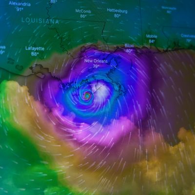
Working with partners at DLR, Kondrateva learned that satellite imagery is critical for disaster response: DLR satellites can spot and respond to wildfires, identify infrastructure damaged by earthquakes and tsunamis, and assess the damage from catastrophic floods.
When severe wildfires swept across California a few years ago, a DLR satellite mission called FireBIRD (Fire BiSpectral InfraRed Detector) monitored the temperature and intensity of the blazes and provided emergency responders in California with maps of the hottest fire areas. “I want to make all that more efficient,” Kondrateva says. “It may take too long to send the images to the ground for analysis. The more information you can get on a satellite directly, the better.”
The payoff could be huge – updated maps in hours, rather than days. “A lot of the data satellites collect is poor quality, or not needed,” she says. “If you’re doing fire detection, for example, you don’t always need a picture of the fires, you just need to know where they are.”
"A lot of satellite data is poor quality or expendable. In fire detection, for example, you don't always need an image of the fires, you just need to know where they are."
Olga Kontrateva, doctoral researcher at HEIBRiDS
That’s a problem because the models usually used to classify images, called neural networks, are both large and computationally demanding. On board a satellite, computing power is a precious commodity – and any new models also have to be transmitted up to the satellite, in the tight windows when it’s in range. To cope, “I’m working on an algorithm to compress the models to make them smaller and need less computational resources,” Kondrateva says.
From linguistic research to programming
At first glance, the leap from linguistics to low Earth orbit may seem huge. But Kondrateva says it was a natural progression: She learned computer programming as part of her linguistics research. She soon shifted her focus from human languages to computer languages, earning computer science degrees from Humboldt University and working as an engineer. “In the beginning I was trying to understand how languages worked internally,” she explains with a smile. “I was most interested in systems.”
Part of Kondrateva’s master’s degree dealt with how networks of satellites communicated with each other. When it came time to choose a PhD topic, she gravitated to space applications once again – and to HEIBRiDS, which gave her an opportunity to apply her computer science background in a new way. “I found data science exciting and wanted to learn something new,” she says. “Computer science, data science and satellites are a very nice combination.”
Kondrateva’s wide-ranging background makes her a good fit at HEIBRiDS. The school’s interdisciplinary mix has been helpful as the St. Petersburg native moves into yet another new area of research.
Like her fellow PhD students, Kondrateva has advisers from two different institutions to ensure interdisciplinarity. HEIBRiDS students meet every two weeks for PhD seminars and data science lectures, and follow a common curriculum as they work towards their doctorates.
Kondrateva says colleagues from other disciplines help her pinpoint key data science research questions and avoid duplicating work already done by other scholars. “At HEIBRiDS if anybody has a problem, they can always ask,” she says. “The communication is really good.”
Text: Andrew Curry